

GPS Jamming and Spoofing, Their Effects on Piloting Operations
The maritime industry has undergone a transformation in recent years, becoming increasingly dependent on electronic systems and satellite-based navigation systems with the rapid integration of technology. However, this dependency has caused certain risk concepts to evolve from mere terms in maritime jargon into concrete threats to daily operations. The concepts of jamming and spoofing have become threats that we hear more frequently, especially following the Russia-Ukraine War and regional conflicts in the Middle East and the Red Sea, and we have even experienced them in the areas where we operate vessels or provide piloting services.
Since the introduction of satellite positioning systems on ships, there have been legends about the potential risks of these systems, including the possibility that they could be turned off by the countries that own these satellites or that they could display incorrect position information. I am sure many of us have heard these topics since the systems were first implemented. During my student years, our late teacher Güven Tuncer, who taught us the intricacies of finding positions at sea and plotting positions on paper charts, shared a detail he noticed while reviewing the internship notebook of a student who had just returned from a long internship. The intern noted that although his ship was sailing in the Black Sea, the GPS device showed a position in a completely different part of the world and on land for a period of time. While recounting this incident, our teacher pointed out that satellite systems could sometimes be tested in this manner by the countries that own them, advising us never to fully trust electronic devices and to master traditional methods. Thanks to the additional satellites (DGPS) that have developed, the system provides real-time and continuous position information with a precision that has dropped to below one meter without requiring any manual calculations, offering a revolutionary ease in maritime operations. This effortless high reliability, which eliminates the complex mathematical calculations of traditional methods and the risks of mispositioning due to human error in this process, has made us forget the possibility that GPS systems could be manipulated or lead to major accidents throughout our maritime lives.
In this article, I will examine the concepts of jamming and spoofing not only within a theoretical framework but also in terms of their operational reflections on the bridge, recent maritime accidents, and particularly their effects on piloting services.
The Concepts of GPS Jamming and Spoofing
GNSS, or Global Navigation Satellite Systems (GPS, Galileo, GLONASS, etc.), send low-power radio signals from satellites positioned in orbit to ships or receiving stations. Since GPS is the most widely known and used system in the industry, interventions targeting these systems will be defined in the maritime industry as GPS in the remainder of the article. The weak nature of the signals coming from GPS satellites makes them extremely vulnerable to malicious interventions that may come from outside. These interventions can generally be divided into two main groups:
Jamming and Spoofing.
Sinyal Karıştırma (Jamming): Küresel seyir uydu sistemlerinin çalıştığı frekans aralığında, uydu sinyalinden çok daha yüksek ve güçlü yapay bir gürültü yani frekans yayınlanması suretiyle hedef alınan bölgedeki alıcıların uydu sinyallerini algılamasının engellenmesi olayıdır. Sonuç olarak sistem kilitlenir, maruz kalınan süre boyunca uydulardan pozisyon bilgisi alınamaz ve gemi köprüüstündeki seyir cihazlarından anında sesli ve görsel alarmlar alınmaya başlanır.
Sinyal Sahteciliği (Spoofing): Jamming'den çok daha karmaşık bir siber saldırı türü olan spoofing’de uydu sinyallerini birebir taklit eden sahte veriler üretilerek geminin GPS alıcısı kandırılır. Cihaz herhangi bir arıza olduğunu fark etmez ve normal çalıştığını zanneder. Ancak geminin hesaplanan konumu, hızı ve rotası gizlice manipüle edilmiştir.
Although the concepts of jamming and spoofing are very similar, the fundamental differences between them can be summarized in the table below:
|
Feature |
Jamming |
Spoofing |
|
Operating Mechanism |
Suppression of satellite signals with high frequency |
Deceiving and manipulating the satellite receiver with false signals |
|
System Response |
Signal loss and interruption, freezing of GPS screens |
The system appears normal but the position information is incorrect |
|
Bridge Effect |
Instantaneous and multiple alarms in navigation devices |
There is no alarm, and the devices display false position information |
|
Detectability |
It is easy for personnel to detect with alarm sounds |
Requires visual verification and checks to be noticed |
General Risks and Their Effects on Navigation Safety
Gemide GPS verilerinin kaybı veya manipülasyonu, sadece harita üzerindeki pozisyonun silinmesi anlamına gelmemektedir. ECDIS, AIS ve otopilot gibi köprüüstü sistemleri doğrudan GPS verileriyle çalışmaktadır. Featurele AIS cihazları, hedeflerin konum, hız ve rota gibi dinamik verilerini doğrudan uydu sistemlerinden aldığı için; bölgesel bir jamming durumunda etraftaki gemiler de kendi pozisyonlarını yayınlayamaz hale gelir. Sonuç olarak gemi bir nevi körleşir, ekranlardaki AIS hedefleri kaybolur ve köprüüstünde ciddi bir alarm karmaşası yaşanır.
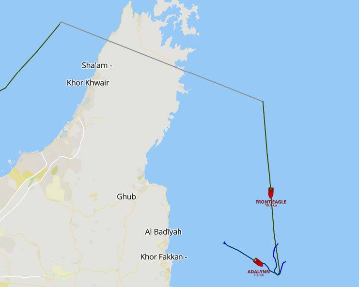
The risk that is much more insidious and critical than the scenario of complete signal loss is the cases of spoofing, where data is secretly manipulated. While the vessel is actually heading towards a shallow area, the ECDIS screen may show that it is navigating in safe waters. These risks are not merely theoretical possibilities; they are established facts confirmed by bitter experiences in the recent past. For example, in June 2025, near the Strait of Hormuz, intense GPS spoofing activities were reported in the collision incident between the VLCC "Front Eagle" and the Suezmax "Adalynn" tankers, and it was observed that the AIS route traces of the vessels crossed over land masses. This incident, which occurred among vessels carrying hazardous cargo, is considered one of the most concrete examples where manipulated position information directly led to physical conflict. The severe fire and environmental pollution that occurred after the collision is also the clearest evidence of how devastating the consequences of even a tiny position manipulation on digital screens at sea can be.
In such a signal manipulation, the vessel broadcasts through the AIS device
Due to incorrect position information, erroneous AIS location data will also be transmitted to nearby vessels or authorities such as Vessel Traffic Services. If AIS data is used on ARPA radar, ghost ship routes will emerge. One of the most dangerous points is the possibility that ship personnel may lose awareness of this issue due to the normalization of such interventions in certain areas caused by ongoing global wars. Over time, ship personnel may become desensitized to constantly ringing malfunction alarms, which can lead to overlooking potential real dangers and missing a vital threat that is not GPS-related. Additionally, the simultaneous presentation of conflicting data from multiple devices will increase the cognitive load on the bridge team, hindering their ability to make correct decisions during a crisis.
Effects on Pilotage Operations and Ship Maneuvers
A GPS failure occurring in open waters can be tolerated using alternative traditional navigation methods (such as celestial navigation or dead reckoning). However, the margin for error will be quite low in waters where ships are approaching ports, navigating narrow channels, and encountering navigation hazards along with heavy vessel traffic.
Port areas and narrow channels are inherently restricted areas where ships pass very close to each other and where depths fall below limits. Even during these routine maneuvers, there is already a significant alarm traffic on the bridge due to warnings such as CPA (Closest Point of Approach), shallow water, or course deviation. Indeed, the International Maritime Pilots' Association (IMPA) has recently brought to international attention how the alarm chaos and unnecessary noise on the ship's bridge during pilotage operations distract pilot captains through a special survey study it conducted. When the results of this survey conducted by IMPA are officially announced, I plan to analyze the obtained data and the effects of alarm fatigue on maneuver safety in detail in a different article in the future. However, one clear fact at this stage is that adding false and constant alerts caused by GPS spoofing or jamming to this routine alarm situation, which already significantly increases the cognitive load on the bridge team, can complicate the decision-making process of the pilot captain managing the maneuver during a crisis in narrow waters.
The announcement titled "Request for Information on GNSS Spoofing and Jamming Incidents," published by the Turkish Pilots Association (TKKD) on March 10, 2026, draws attention to this vital issue facing maritime navigation. In the announcement, it is stated that as part of a large-scale study conducted by the European Maritime Pilots Association (EMPA), pilot captains operating in Turkey are requested to document real intervention cases they encounter in the field to be used in the international analysis of risks to maritime safety and the creation of new regulations. Indeed, in a joint statement submitted to the European Commission in March 2025 by EMPA, the European Tugowners Association (ETA), and the European Dredging Association (EuDA), the seriousness of this threat was once again emphasized. The statement clearly expresses that the presence of highly trained professionals, such as pilot captains who will take the initiative to safely manage the vessel during these unpredictable crisis moments when digital autonomous systems fail or are manipulated, is of vital importance.
edilmiştir.
Kılavuzluk operasyonlarına tabi seyir bölgeleri özelinde değerlendirdiğimizde, özellikle bazı ülkelerdeki uzun kanal seyirlerinde kılavuz kaptanların gemiye yanlarında getirerek önemli karar destek sistemlerinden birisi olarak faydalandıkları, bilinen isimleri ile PPU (Portable Pilot Unit) taşınabilir üniteler yüksek hassasiyetli konum, hız ve dönüş oranı (ROT) gibi seyir verilerini sağlamak için büyük oranda bağımsız uydu sensörleri ve Gerçek Zamanlı Kinematik (RTK) düzeltmeleri uygulayarak çalışmaktadır. Ancak bu cihazların kullanımı sırasında yaşanabilecek profesyonel bir spoofing saldırısı, PPU'nun sağladığı verileri manipüle ederek telafisi mümkün olmayan kazalara yol açabilir. Müdahale sadece statik bir konum kayması değil; aynı zamanda hız vektörleri ve dönüş oranı (ROT) üzerinde yapılan küçük müdahaleler ile kılavuz kaptanın geminin momentum algısını bozmayı hedefleyebilir. Bahsettiğimiz bu teorik risklerin sahadaki yansıması oldukça çarpıcıdır. Featurele Kuzey Avrupa'da artan elektronik manipülasyon vakaları nedeniyle, Norveç Kıyı İdaresi (NCA) gibi kurumlar seyir emniyetine yönelik ciddi uyarılar yayımlamaktadır. Sahadan gelen raporlar ve kılavuz kaptanların geri bildirimleri hem gemi donanımlarında hem de PPU cihazlarında artan sıklıkla GPS sinyal kaybı veya müdahale tecrübe edildiğini göstermektedir. Bu yüksek risk nedeniyle Hollanda Kılavuzluk Teşkilatı (Loodswezen) da dâhil olmak üzere pek çok Avrupa ülkesi, PPU cihazlarını özel jamming ve spoofing uyarı sistemleriyle donatma kararı almıştır. Ayrıca yeni nesil PPU donanımlarına Ataletsel Ölçüm Ünitelerinin (IMU / INS) entegre edilmeye başlanması, GPS sinyalleri kopsa veya manipüle edilse dahi manevranın emniyetle iptal edilebilmesi için ihtiyaç duyulan kritik birkaç dakikalık doğru ataletsel veriyi sağlama yönünde atılan önemli bir teknolojik adım olmuştur.
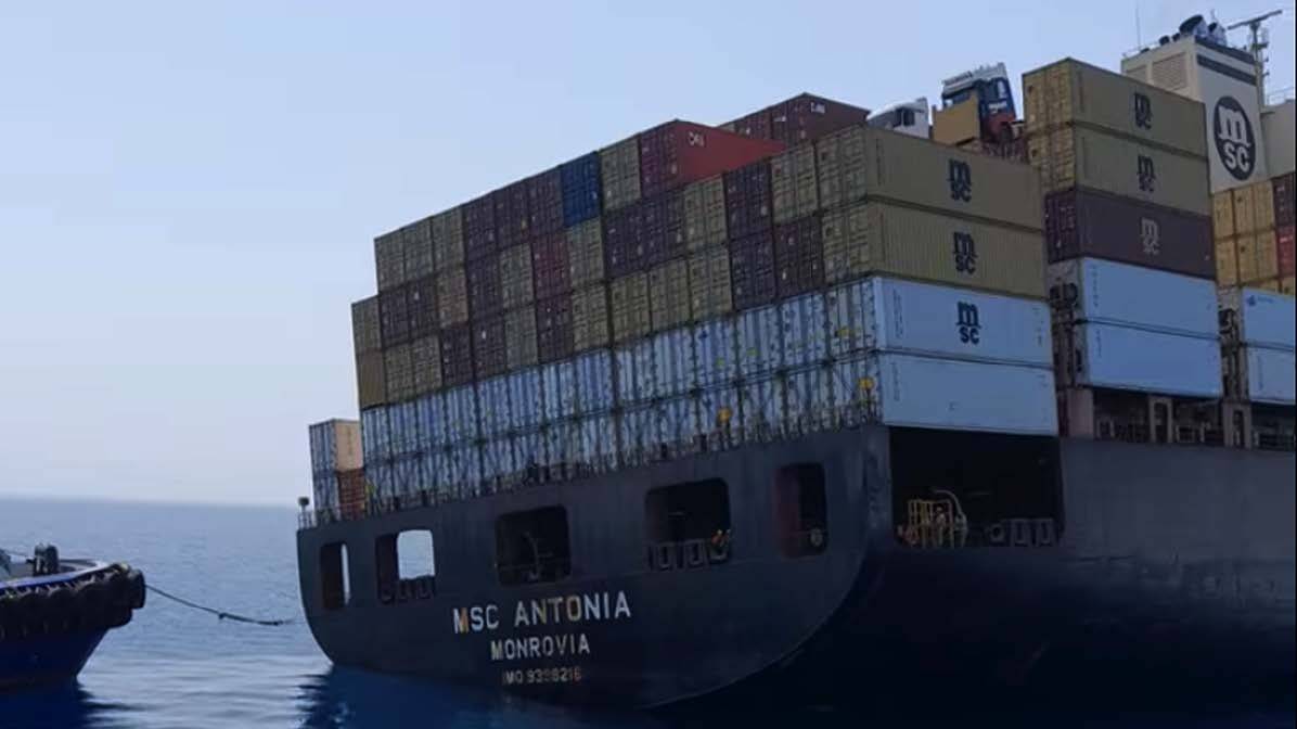
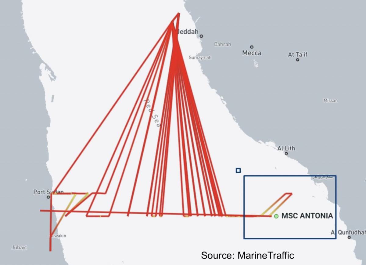
One of the most recent and striking examples of the operational consequences of GPS interventions occurred on May 11, 2025, in the Red Sea. The container ship MSC ANTONIA, with a capacity of 7,000 TEU, ran aground approximately 100 nautical miles south of Jeddah. Just two days before the accident, a dense GPS signal jamming warning reported by UKMTO in the region, along with inconsistent and irregular route traces in the ship's AIS records, revealed that the accident was directly caused by GPS manipulation. In fact, the tugboats that came to assist in the area were also exposed to similar signal anomalies, seriously complicating the coordination and position verification processes between the main vessel and the rescue elements. This incident has once again highlighted the vital importance of signal security on routes requiring high-precision positioning as an example of a risk threatening the safety of pilotage in port approaches.
As all these cases demonstrate; particularly in narrow channels, the mismatch between radar images and ECDIS data creates a dangerous contradiction between the visual perception obtained by the pilot from outside and the instrumental data.
Regarding tug operations, which are another critical component of ship maneuvering; there have been no directly reported accident effects of jamming and spoofing incidents in the literature. Although tugs are exposed to these signal manipulations, their high maneuverability, geographical familiarity in narrow waters, and the nature of the operation often allow them to use visual navigation methods, thus eliminating these risks. Additionally, the difference in frequency bands between the GPS system and the VHF radio frequency bands, which serve as the primary communication tool between the pilot and the tug, also facilitates the continuity of communication safety in cases of spoofing or jamming.
Management of Risks and Return to Traditional Positioning Methods
To successfully manage the risks associated with GPS, it is crucial to perform position verification using alternative methods that align with the dynamics of the navigated area, along with awareness and a state of suspicion. The positioning methods to be applied to ensure navigation safety can be categorized based on the ship's location. In areas such as coastal navigation and narrow waters, where land masses can be referenced; traditional methods such as adding radar images to the ECDIS screen (radar overlay), confirming the ship's position using parallel indexing, and taking visual bearings should be given absolute priority, independent of GPS data. Additionally, cross-checking the depths read from the depth sounder with the contours on the ECDIS chart will be another critical step in detecting manipulation. On the other hand, in open sea navigation where no land masses can be referenced; controlling the approximate position using gyro compass and dead reckoning techniques, along with traditional astronomical navigation applications, will serve as alternatives to ensure navigation safety during moments when GPS leaves us in the dark.
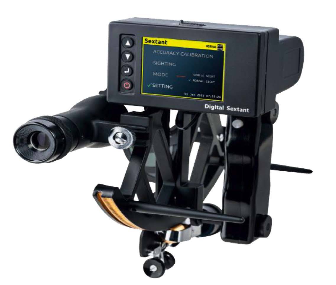
Although astronomical navigation is the sole alternative to electronic navigation in open sea navigation, the lengthy calculation processes and practical difficulties can pose a barrier for today's mariners. At this point, innovative solutions that blend technology with traditional methods come into play. Indeed, one of the recent developments that inspired me to prepare this article was the professional exchange of information I had with South Korean Dr. Young Sub Lee through LinkedIn. The digital sextant developed by Dr. Lee and his team, which is currently integrated into the standard navigation equipment of the South Korean Navy, combines traditional celestial navigation principles with modern algorithms to perform independent position calculations in under a second. Dr. Lee states that the aim of his innovative approach is not to completely replace existing electronic navigation systems, but to provide ships with a rapid and reliable positioning reference during crisis moments when GPS signals are jammed or manipulated.
Beyond all these operational and technical risks, another point that should not be overlooked is how the legal liability of the ship captain and the pilot will be evaluated from the perspective of maritime law in the event of a potential accident caused by manipulated data due to cyber interventions, which will be a separate topic of discussion.
It is precisely at this point that pilots are rising from being mere local information providers in increasingly digital ship bridges to the position of ultimate cyber-physical verifiers who confirm the truth through visual and experiential methods during crisis moments when electronic systems are manipulated.
Dr. Capt. Mustafa SÖKÜKCÜ
Sources Utilized:
-
Turkish Pilots Association (TKKD). “Request for Information on GNSS Spoofing and Jamming Incidents,” announcement dated March 10, 2026.
-
Riviera Maritime. European tug owners and pilots: safety is paramount for EU port strategy. https://www.rivieramm.com/news-content-hub/news-content-hub/european-tug-owners-and-pilots-safety-is-most-important-for-port-strategy-84300
-
Lee, Y. S. Korea digital sextant: LEEYOUNG SND_DS_Ev2.0 (Technical Presentation / Company Brochure).
-
Maritime Global Security (2nd Edition). Jamming and Spoofing of Global Navigation Satellite Systems (GNSS). https://www.maritimeglobalsecurity.org/media/2cwigtc4/2025-jamming-and-spoofing-2nd-ed-web.pdf
-
Riviera Maritime. MSC box ship grounds in apparent GPS jamming incident. https://www.rivieramm.com/news-content-hub/news-content-hub/msc-box-ship-grounds-in-apparent-gps-jamming-incident-84821
-
Cydome. Tankers collide in the Gulf, analysts suspect GPS jamming. GEOD. How a PPU determines accurate position and speed.
-
GEOD. How a PPU determines accurate position and speed. Schuttevaer. Rotterdam Port PPU Usage and Digital Navigation Reports.
-
GEOD. How a PPU determines accurate position and speed. https://geodproducts.com/vessel-position-accuracy-pilots-need-ppu/
-
Schuttevaer. Rotterdam Port PPU Usage and Digital Navigation Reports. https://www.schuttevaer.nl/
Source: www.denizhaber.com