


With the rapid integration of technology, the maritime industry has undergone a profound transformation in recent years, becoming increasingly dependent on electronic equipment and satellite-based navigation systems. However, this dependence has caused certain risk concepts to evolve from mere terms in maritime jargon into concrete threats to daily operations. The concepts of jamming and spoofing have become threats that we hear about more frequently, especially following the Russia-Ukraine War and regional conflicts in the Middle East and the Red Sea, and even experience firsthand on the vessels we work on or in the port areas where we provide pilotage services.
Since satellite positioning systems were first introduced to ships, myths regarding their potential risks, such as the possibility of them being shut down by the countries that operate them or their potential to display false position data, are topics that I am sure most of us have heard since the early days of their use. During my student years, our late instructor Güven Tuncer, who taught us the intricacies of finding a position at sea and plotting on paper charts, shared a detail he noticed while reviewing the training record book of a cadet returning from a long sea term. The cadet had noted that, although his ship was sailing in the Black Sea, the GPS device temporarily displayed a position in a completely different part of the world, directly over land. When recounting this incident to us, our instructor pointed out that the states owning the satellite systems might occasionally run such tests, advising us never to rely solely on electronic devices and emphasizing the necessity of mastering traditional navigation methods.
Thanks to supplementary satellites (such as DGPS), the system's ability to provide instantaneous and continuous position data with sub-meter accuracy, without requiring any manual calculation, has offered a revolutionary convenience in maritime operations. This effortless and high reliability, which eliminated the complex mathematical calculations of traditional methods and the risks of incorrect positioning due to human error, has made us forget throughout our maritime careers the possibility that the GPS system could be manipulated or lead to catastrophic accidents.
In this article, I will examine the concepts of jamming and spoofing not merely within a theoretical framework, but through the axis of their operational reflections on the bridge, recent maritime casualties, and particularly their impacts on pilotage services.
The Concepts of GPS Jamming and Spoofing
GNSS, or Global Navigation Satellite Systems (such as GPS, Galileo, GLONASS, etc.), transmit low-power radio signals from orbiting satellites to vessels or receiver stations. Since GPS is the most widely known and utilized system in the sector, the remainder of this article will refer to these interferences under the generally accepted maritime industry term of GPS.
The inherently weak nature of signals originating from GPS satellites makes them
highly vulnerable to malicious external interference. Such interventions are generally categorized into two main groups: signal jamming and signal spoofing:
Signal Jamming: This is the act of preventing receivers in a targeted area from detecting satellite signals by broadcasting artificial noise, or frequency, that is much higher and more powerful than the satellite signal within the frequency range where global navigation satellite systems operate. Consequently, the system locks up, position data from the satellites cannot be received for the duration of the exposure, and instant audible and visual alarms are triggered on the bridge's navigation equipment.
Signal Spoofing: A much more sophisticated type of cyberattack than jamming, spoofing involves deceiving the vessel's GPS receiver by generating fake data that perfectly mimics satellite signals. The device fails to detect any malfunction and assumes it is operating normally. However, the vessel's calculated position, speed, and course have been covertly manipulated.
Although the concepts of jamming and spoofing may appear quite similar, the fundamental differences between them can be summarized in the table below:

General Risks and Impacts on Navigation Safety
The loss or manipulation of GPS data onboard a vessel means much more than simply the disappearance of a position on the chart. Critical bridge systems, such as ECDIS, AIS, and autopilot, operate directly using GPS data. Particularly because AIS devices acquire dynamic data of targets, such as position, speed, and course, directly from satellite systems, vessels in the vicinity also become unable to broadcast their own positions during a regional jamming incident. Consequently, the vessel effectively experiences a state of blindness; AIS targets disappear from the screens, and severe alarm chaos ensues on the bridge.
An even more insidious and critical risk than the blindness scenario caused by total signal loss is the occurrence of spoofing incidents, where data is covertly manipulated.
While a vessel may actually be heading towards a shallow area, it might appear to be sailing in safe waters on the ECDIS screen.
These risks are not merely theoretical possibilities; they are realities cemented by bitter experiences in the recent past. For instance, during the collision between the VLCC “Front Eagle” and the Suezmax tanker “Adalynn” off the coast of Fujairah, near the Strait of Hormuz in June 2025, intense GPS spoofing activities were reported in the region, and the AIS tracks of the vessels were observed passing directly over landmasses. This incident, which occurred recently between vessels carrying dangerous cargo, is considered one of the most concrete examples of how manipulated position data can directly lead to a physical collision. The severe fire and environmental pollution that broke out following the collision serve as the clearest proof of how devastating a tiny position manipulation on digital screens at sea can be.
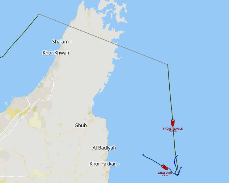
Figure 1: AIS data tracks recorded prior to the collision of the Front Eagle and Adalynn tankers off Fujairah in June 2025 (Source: Cydome, 2025)
In such signal manipulations, because the position data broadcasted via the vessel's AIS device will be incorrect, surrounding vessels or authorities like Vessel Traffic
Services (VTS) will also receive false AIS position information. If AIS data is overlaid on the ARPA radar, phantom ship tracks will emerge. One of the most dangerous aspects of this issue is the loss of situational awareness among the ship's crew regarding this specific topic. Due to ongoing global conflicts, such interferences have become commonplace in certain regions. Ship crews gradually experience alarm fatigue due to the continuously sounding malfunction alarms. This situation paves the way for potential genuine hazards to be overlooked and for a critical, non-GPS-related danger to be missed. Furthermore, the simultaneous presentation of conflicting data by multiple devices increases the cognitive load of the bridge team, thereby impairing their ability to make accurate decisions during a crisis.
Specific Impacts on Pilotage Operations and Ship Maneuvering
A GPS failure occurring in the open sea can be tolerated using alternative traditional navigation methods (such as celestial navigation or dead reckoning). However, the margin of error is exceptionally low in waters where vessels enter port approaches and navigate through narrow channels full of navigational hazards and dense marine traffic. Port areas and narrow channels are, by nature, restricted spaces where ships pass very close to one another and depths drop below safe limits. Even during these routine maneuvers, the bridge already experiences heavy alarm traffic due to warnings such as CPA (Closest Point of Approach), shallow water, or cross-track error.
Indeed, the International Maritime Pilots' Association (IMPA) recently brought the issue of how alarm chaos and unnecessary noise on the bridge during pilotage operations distract maritime pilots to the international agenda through a special survey. When the results of this survey conducted by IMPA are officially announced, I plan to analyze the obtained data and the effects of alarm fatigue on maneuvering safety in detail in a future article. However, one fact is already clear: adding fake and continuous warnings caused by GPS spoofing or jamming to this ordinary alarm situation, which already significantly increases the cognitive load of the bridge team under normal conditions, can severely complicate the decision-making mechanism of the pilot managing the maneuver in restricted waters during a crisis.
The announcement titled "Information Request Regarding GNSS Spoofing and Jamming Incidents," published by the Turkish Maritime Pilots' Association (TKKD) on March 10, 2026, also draws attention to this vital problem facing the maritime industry. Within the scope of a comprehensive study conducted by the European Maritime Pilots' Association (EMPA), this announcement requested pilots working in Turkey to record and report real interference cases they encounter in the field. These reports are intended to be used in analyzing the risks to maritime safety at an international level and in drafting new regulations. Furthermore, the seriousness of this threat was reiterated in a joint statement submitted to the European Commission in March 2025 by EMPA, the European Tugowners Association (ETA), and the European Dredging Association (EuDA). The statement explicitly highlighted that in such unpredictable moments of crisis, where digital autonomous systems fail or are manipulated, the presence of highly trained professionals, such as maritime pilots who take the initiative to safely navigate the vessel, is of vital
importance.
When evaluated specifically in navigational areas subject to pilotage operations, especially during long channel transits in certain countries, pilots bring Portable Pilot Units (PPUs) on board as a crucial decision-support system. These devices largely rely on independent satellite sensors and apply Real-Time Kinematic (RTK) corrections to provide highly accurate navigational data such as position, speed, and Rate of Turn (ROT). However, a professional spoofing attack during the use of these devices could manipulate the data provided by the PPU, potentially leading to irreversible accidents. Such manipulation does not merely consist of a static position shift; through minor alterations to speed vectors and the ROT, the intervention aims to disrupt the pilot's perception of the ship's momentum. The field reflections of these theoretical risks are quite striking. Particularly in Northern Europe, due to increasing incidents of electronic manipulation, authorities like the Norwegian Coastal Administration (NCA) are issuing serious warnings regarding navigational safety. Field reports and feedback from pilots indicate an increasing frequency of GPS signal loss or interference experienced in both ship equipment and PPU devices. Because of this high risk, many European countries, including the Dutch Maritime Pilots' Organization (Loodswezen), have decided to equip PPU devices with special jamming and spoofing warning systems. Additionally, the integration of Inertial Measurement Units (IMU/INS) into next-generation PPU hardware has been a significant technological step. This ensures the provision of the crucial few minutes of accurate inertial data needed to safely abort a maneuver, even if GPS signals are lost or manipulated.
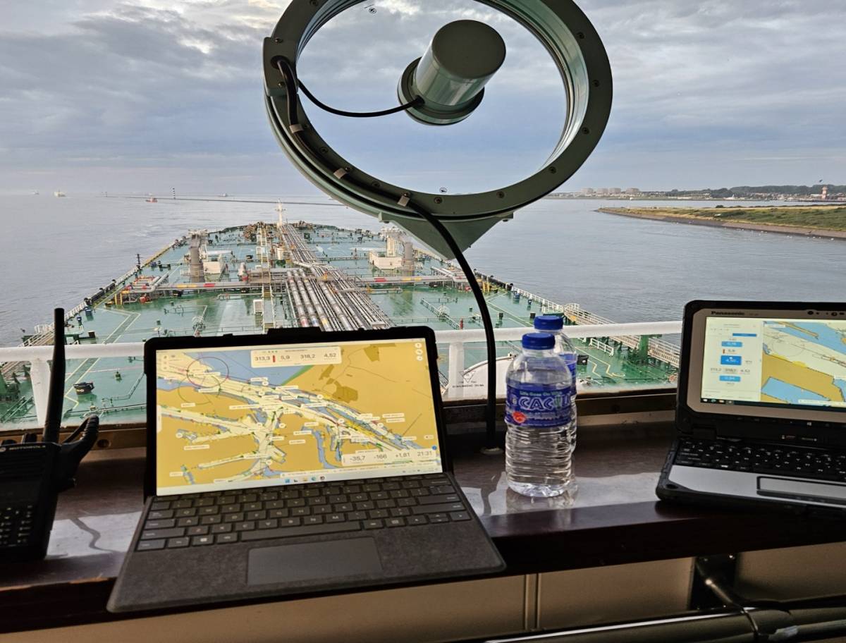
Figure 2: A maritime pilot using a PPU device brought on board at the Port of Rotterdam (Source: Schuttevaer)
One of the most recent and striking examples of the operational consequences of GPS interference occurred in the Red Sea on May 11, 2025. The 7,000 TEU container ship, MSC ANTONIA, ran aground approximately 100 nautical miles south of Jeddah. A severe GPS jamming warning reported in the area by UKMTO just two days before the accident, coupled with the inconsistent and erratic track logs in the ship's AIS data, revealed that the grounding was a direct result of GPS manipulation. Moreover, the fact that the tugboats arriving to assist also suffered from similar signal anomalies severely complicated coordination and position verification processes between the casualty vessel and the salvage units. This incident once again underscored the vital importance of signal security on routes requiring high-precision positioning, serving as a prime example of a risk that also threatens pilotage safety during port approaches.
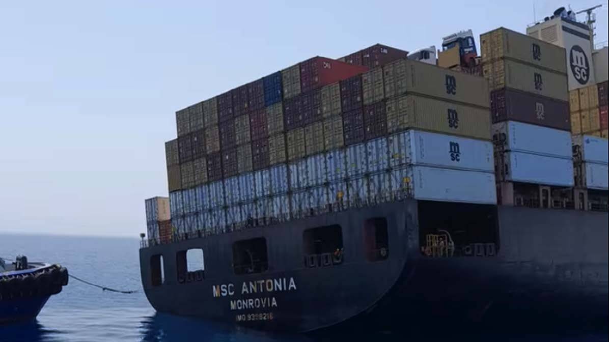
Figure 3: The MSC ANTONIA, which ran aground in the Red Sea due to GPS jamming/spoofing (Source: Riviera Maritime)
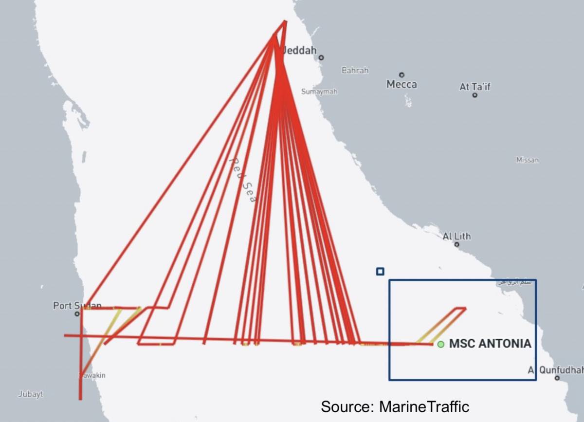
Figure 4: AIS track recorded prior to the grounding of the MSC ANTONIA. The abnormal deviations in the course due to GPS interference (jamming/spoofing) are notable (Source: Splash247)
As demonstrated by all these cases, the mismatch between the radar image and ECDIS data, particularly in a narrow channel, creates a dangerous contradiction between the visual perception the pilot obtains by looking outside and the instrumental data.
Regarding tugboat operations, which are another critical component of ship maneuvering; there has not yet been a direct accident consequence of jamming and spoofing incidents reported in the literature. Although tugboats are exposed to these signal manipulations, they can generally eliminate these risks thanks to their high maneuverability, geographic familiarity with restricted waters, and the fact that they mostly rely on visual navigation methods due to the nature of their operations. Furthermore, the fact that the VHF radio frequency bands, the primary communication tool between the pilot and the tugboat, operate on a different frequency band than the GPS system allows communication safety to be maintained during jamming or spoofing situations.
Risk Management and the Return to Traditional Positioning Methods
To successfully manage GPS-related risks, maintaining situational awareness, a critical approach, and verifying positions through alternative methods suitable for the dynamics of the navigation area are of utmost importance. The positioning methods to be applied to ensure navigational safety can be categorized based on the vessel's location. In areas such as coastal navigation and narrow channels where landmarks are available for taking bearings, absolute priority must be given to traditional methods independent of GPS data. These include applying a radar overlay onto the ECDIS screen, verifying the ship's position using parallel indexing, and taking visual bearings. Furthermore, cross-checking the depths read from the echo sounder with the contour lines on the ECDIS chart will be another critical step in detecting manipulation.
On the other hand, during open sea navigation where no landmarks are available for bearings, checking the approximate position using gyro compass and log techniques (dead reckoning) and traditional celestial navigation practices will serve as alternatives to ensure navigational safety in moments when GPS leaves the vessel in the dark. Although celestial navigation is the sole alternative to electronic navigation in the open sea, lengthy calculation processes and practical difficulties in application can pose a significant barrier for modern seafarers. At this point, innovative solutions that blend technology with traditional methods come into play. Indeed, one of the recent developments that inspired me to prepare this article was the professional exchange of information I had with South Korean Dr. Young Sub Lee after connecting via LinkedIn. The digital sextant, developed by Dr. Lee and his team and currently integrated into the standard navigation equipment of the South Korean Navy, combines traditional celestial navigation principles with modern algorithms to independently calculate a position in under a second. Dr. Lee states that the objective of his innovative approach is not to completely replace existing electronic navigation systems, but to provide a rapid and reliable positioning reference to ships during crises where GPS signals are jammed or spoofed.
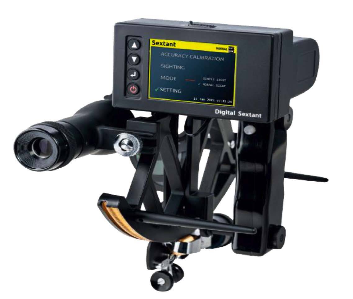
Figure 5: The Digital Sextant, blending celestial navigation principles with digital algorithms (Source: Leeyoung SND)
Beyond all these operational and technical risks, another aspect that must not be forgotten is how the limits of legal liability for the ship's master and the maritime pilot in a potential accident caused by manipulated data from cyber interferences will be evaluated under maritime law, a subject that will certainly spark a separate debate.
It is precisely at this point that maritime pilots go beyond being mere local knowledge providers on increasingly digitalized ship bridges; they are rising to the position of ultimate cyber-physical validators who verify the truth through visual and experience-based methods during moments of crisis when electronic systems are manipulated.
Capt. Mustafa SÖKÜKCÜ (Ph.D.)
References:
Turkish Maritime Pilots’ Association (TKKD). “Information Request Regarding GNSS Spoofing and Jamming Incidents”, Announcement dated March 10, 2026
Riviera Maritime. European tug owners and pilots: safety is paramount for EU port strategy. https://www.rivieramm.com/news-content-hub/news-content-hub/european-tug-owners-and-pilots-safety-is-most-important-for-port-strategy-84300
Lee, Y. S. Korea digital sextant: LEEYOUNG SND_DS_Ev2.0 (Technical Presentation / Company Brochure).
Maritime Global Security (2nd Edition). Jamming and Spoofing of Global Navigation Satellite Systems (GNSS). https://www.maritimeglobalsecurity.org/media/2cwigtc4/2025-jamming-and-spoofing-2nd-ed-web.pdf
Riviera Maritime. MSC box ship grounds in apparent GPS jamming incident. https://www.rivieramm.com/news-content-hub/news-content-hub/msc-box-ship-grounds-in-apparent-gps-jamming-incident-84821
Cydome. Tankers collide in the Gulf, analysts suspect GPS jamming. https://www.cydome.com/blog/tankers-collide-in-the-gulf-analysts-suspect-gps-jamming
Splash247. MSC boxship grounds in the Red Sea amid GPS jamming reports. https://splash247.com/msc-boxship-grounds-in-the-red-sea-amid-gps-jamming-reports/
GEOD. How a PPU determines accurate position and speed. https://geodproducts.com/vessel-position-accuracy-pilots-need-ppu/
Schuttevaer. Rotterdam Port PPU Usage and Digital Navigation Reports. https://www.schuttevaer.nl/