

ISTANBUL STRAIT AND ITS FAMOUS CURRENTS
A Nautical and Historical Perspective
1. Introduction
The Istanbul Strait—commonly known as the Bosphorus—is a natural waterway that stretches approximately 32 kilometers between the Black Sea and the Sea of Marmara, with an average width of about 1.5 kilometers. This strait, a defining landmark of the city’s skyline and cultural identity, also holds strategic significance in global maritime navigation. When measured along the coastline, the European shore runs about 55 kilometers, whereas the Anatolian shore is roughly 35 kilometers. This stark difference is a clear indication of how deeply indented and winding the European side is, giving the Bosphorus its unique shape.
From antiquity to modern times, the primary challenge that has consistently preoccupied mariners navigating the Bosphorus is the current. Even captains of massive modern vessels, boasting powerful engines, have to tread carefully to avoid the infamous pitfalls of the Bosphorus current. The local mantra “there’s no joking with the current” reflects the formidable nature of these waters and the penalties for underestimating them.
Another critical factor in the Strait is the wind regime. The predominant winds, Lodos (from the southwest) and Poyraz(from the northeast), can drastically affect both the surface level of the sea and the direction and intensity of the currents. For instance, following a prolonged period of strong Poyraz, one might observe that passenger ferry piers at Beşiktaş are notably lower than usual. In severe cases, this can be dangerous enough that passengers risk hitting their heads when boarding the ferry. The underlying reason is that the wind has driven the waters away, effectively lowering the sea level and amplifying the outflow from the Black Sea to Marmara, thereby sharpening the current.
Conversely, a strong Lodos can accumulate waters at the southern entrance of the Strait, temporarily reversing the normal north-to-south flow. This opposite flow, known as the “Orkoz current,” can reach speeds up to 6–7 knots, imposing serious navigational hazards and sometimes forcing maritime traffic closures in the Bosphorus.
In this article, we will delve deep into the anatomy of these currents, reviewing their causes, types, and dynamic behavior in the Strait. We will also touch upon the long-standing tradition of pilotage (kılavuz kaptanlık), an ancient practice in the Bosphorus, demonstrating that even mythical figures, such as Phineus and Tiphys, were said to have guided early seafarers through these perilous waters. The pilot’s expertise remains as crucial now as it was in antiquity, underscoring why the Istanbul Strait is often called the “spiritual home of pilotage.”
2. Geographic Features of the Bosphorus
2.1. Dimensions and Depth
The narrowest point of the Istanbul Strait lies between Kandilli on the Asian side and Aşiyan on the European side, measuring a mere 698 meters across. At that very spot, the Strait plunges to a depth of around 109 meters, the deepest part of the entire waterway. Thus, the narrowest point is also the deepest, which correlates with some of the strongest currents. Indeed, the swift flow at Kandilli, commonly referred to as the “Şeytan Akıntısı” (“Devil’s Current”), forms when the robust stream from the Black Sea rounds the bend at Küçüksu, hugs Kandilli Point, and barrels on toward Akıntı Burnu.
Moving south from the northern entrance, the average depth gradually decreases. Upon exiting into the Sea of Marmara, the depth can diminish to around 60–70 meters. Farther south of the Strait, depths near Sivriada still remain under 100 meters, but once beyond that point in the Sea of Marmara, the basin deepens dramatically, exceeding 1,000 meters. Toward the Black Sea entrance, by contrast, the transition is more gradual.
2.2. Orientation and Wind Axes
The primary axis of the Strait, roughly from the midpoint of each entrance, is about 25 degrees off true north. Mariners often refer to the course when heading north as 025° and when heading south as 205°. These headings closely align with the dominant Lodos (SW) and Poyraz (NE) winds. Given this parallel alignment, it is only natural that the currents in the Bosphorus respond directly to shifts in these prevailing winds. A few days of strong wind from one direction can drastically change the water levels, resulting in surges or drops along the shore, as regularly witnessed by daily ferry commuters.
2.3. Sea Level Variations and Piers
During a persistent Poyraz, the wind drives Marmara’s surface waters offshore, lowering the levels near the southern part of the Strait. This can be observed at ferry docks in Beşiktaş, where the landings may slope downward more than usual. In such conditions, passengers must watch their heads while boarding. This short-term drop in sea level—sometimes 20–30 centimeters below the norm—testifies to how robust the Bosphorus current can become under strong northeasterly winds. The difference in levels between the Black Sea and the Sea of Marmara can approach one meter in such scenarios.
Similarly, under days-long strong Lodos, surface waters pile up at the southern mouth, reversing the normal flow. Hence, it is primarily these wind changes along the Lodos–Poyraz axis, rather than tidal forces, that drive the water level fluctuations and short-term current reversals in the Istanbul Strait.
3. Formation of the Bosphorus Currents
3.1. A Historical Backdrop: From Antiquity to Modern Times

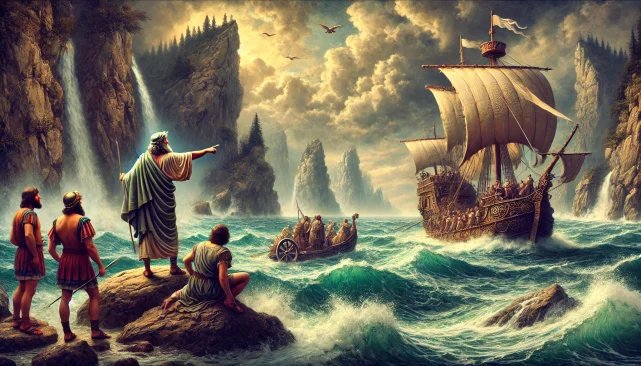
Mentions of strong currents in the Bosphorus date back to the earliest records of seafaring. While the Black Sea was once dubbed “Axeinos” (the inhospitable sea) in antiquity, the Strait’s currents were equally dreaded and woven into mythological tales. One of the famous legends involves Jason and the Argonauts searching for the Golden Fleece. They purportedly sought the help of a local pilot when transiting the Strait. This account is regarded by many as one of the earliest examples of pilotage in maritime history.
In 2004, the then-Secretary-General of the International Maritime Organization (IMO), Efthimios Mitropoulos, declared the Istanbul Strait to be the “spiritual home of pilotage,” alluding to these ancient references. Despite modern engines and advanced navigational aids, the local knowledge of Bosphorus pilots—acquainted with the intricacies of swirling eddies and powerful currents—remains indispensable.
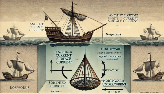
3.2. Surface and Underwater Currents
Two primary layers of current flow through the Strait:
- The Surface Current: Extending from the surface down to about 15 meters, carrying generally lighter and less-saline water from the Black Sea to the Sea of Marmara.
- The Subsurface Current: Beneath a buffer zone of a few meters (around 2–5 meters thick), saltier and heavier water from the Sea of Marmara flows northward, in the opposite direction.
Two main mechanisms underpin this dual-layer flow:
-
Water Level Difference: The Black Sea stands approximately 40 cm higher than the Sea of Marmara, mainly because the Black Sea receives large volumes of freshwater from major rivers (Danube, Dniester, Dnieper, Don). Despite significant annual evaporation, the net influx still elevates the Black Sea’s level compared to Marmara. This difference drives the vigorous surface current southward.
-
Salinity Gradient: With an average salinity of around 1.8%, Black Sea water is significantly fresher (and thus lighter) than the 3.6% salinity found in Marmara and the Aegean Sea. Heavier, saltier water flows as a subsurface current from south to north, opposing the lighter surface flow.
3.3. Speeds and Volumes
The surface current can accelerate to 6–7 knots under ideal conditions, while the subsurface current typically ranges up to around 3 knots. In terms of annual flow, estimates suggest approximately 409 cubic kilometers of water move from the Black Sea to the Sea of Marmara through the surface layer. Meanwhile, some 290 cubic kilometers of dense water travel northward beneath, resulting in a net southbound flow of 120 cubic kilometers each year. Considering the Black Sea’s massive volume of 547,000 cubic kilometers, this net transfer does not drastically alter its overall level.
4. Prehistoric Times and Flood Theories
4.1. The Evolving Geography of the Black Sea
Geological evidence indicates that the Black Sea was once a large freshwater lake around 15,000 years ago, with its level 140 meters lower than today’s. As glaciers melted and global sea levels rose, water from the Black Sea poured through the Bosphorus into the Sea of Marmara, only to have this process reverse some millennia later when Marmara’s water rose and rushed back into the Black Sea. Some scholars connect this dramatic flooding event to legendary narratives of a “Great Flood” in the Epic of Gilgamesh or the Biblical story of Noah.
4.2. Lack of Deepwater Oxygen and Archaeological Finds
Below around 200 meters, the Black Sea’s deeper layers remain devoid of sufficient oxygen—a result of the dense salt layer stratification—which prevents marine life from thriving. This anoxic condition has preserved shipwrecks in remarkable condition. In the late 1990s, the American researcher Robert Ballard discovered a 1,500-year-old wreck off the coast of Sinop at a depth of about 325 meters, astonishingly well-preserved. Additional ancient wrecks from the 4th century BC were also identified. The discovery of submerged human settlements at around 95 meters confirmed that the coastal areas of the Black Sea were inundated after a major marine transgression 7,500–8,000 years ago.
5. The Influence of Winds on Bosphorus Currents
5.1. Seasonal and Short-Term Variations
The flow from large rivers feeding the Black Sea fluctuates with the seasons, raising and lowering the Black Sea’s water level. Combined with daily and periodic wind variations, these short- and medium-term changes impact the Bosphorus current. A 2–3 day spell of strong southwesterly winds (Lodos), for instance, can flip the direction of the main flow, enabling Marmara water to surge northward into the Strait.
5.2. The Orkoz Current
When Lodos persists, piling up water at the southern mouth, the water level near Marmara can exceed the northern side by as much as 60 centimeters, and the flow reverses into an “Orkoz Current.” This reversed current can reach up to 6–7 knots. Under Turkish Straits Maritime Traffic Regulations, the Bosphorus may be closed to vessel traffic if the Orkoz Current exceeds 4 knots.
A striking example occurred in February 1999 with the tanker Spetses (100,000 tons of crude oil). While heading south from the Black Sea, the vessel approached the 90-degree Yeniköy turn under heavy Lodos and Orkoz conditions. It failed to execute the turn, drifted toward the Asian shore, and only managed to stop by anchoring off Çubuklu. This near-disaster could have triggered a major environmental catastrophe had the vessel collided with shoreside fuel depots.
5.3. Etymology of Lodos and Poyraz
“Lodos,” the local name for the SW wind, stems from the Greek word Notos. “Poyraz,” the NE wind, descends from Greek “Boreas,” the mythological personification of the cold wind from Thrace. In ancient mythology, Boreas was said to reside in a cave along the Bosphorus, unleashing frigid blasts to challenge mariners. Today, the Bosphorus continues to experience these dominant winds, with Lodos and Poyraz shaping navigation more than any tidal cycle.
6. Maritime Practices from Ancient Times to Present
6.1. The Origins of Pilotage
The necessity of having a local pilot (kılavuz kaptan) to tackle the Bosphorus currents dates back to antiquity. Whether in the Argonauts’ myth or the maritime annals of the Byzantine and Ottoman eras, captains learned early on that local knowledge was indispensable for contending with fierce eddies and sharp bends. The notion of an old mariner guiding ships through trouble spots—sometimes physically hauling them by ropes along the shoreline—is ingrained in the Strait’s lore.
One legendary example is the statue of “the Old Mariner” (often identified as Phineus) said to have stood by the shore, where seafarers would offer sacrifices hoping for a safe transit. Though the historical statue is long lost, the custom of seeking local expertise never faded.
6.2. Using Weighted Baskets to Harness the Countercurrent
To combat the strong southward surface current, some ancient seafarers employed a clever tactic: they would lower a weight 15–20 meters deep—sometimes a conical wicker basket loaded with stones—to catch the northbound undercurrent. This practice allowed vessels to make headway against the fierce surface flow, an early yet ingenious demonstration of harnessing nature’s forces rather than fighting them outright.
In places like Akıntı Burnu, where the main current ran extremely strong, even such cunning methods sometimes proved inadequate. Mariners would then disembark, and physically haul the vessel around bends with ropes. Fishermen in the Bosphorus also discovered there was a southbound surface current and a northbound bottom current as their nets fell victim to an “S-shape” pull, confirming, long before modern science, that two opposing flows existed in the Strait.
6.3. Mandroklees and the First “Bridge” Across the Strait
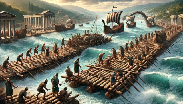
In 512 BC, the Persian King Darius commanded the Samian engineer Mandroklees to construct a bridge of ships for his army to cross the Bosphorus. By linking vessels with ropes, Mandroklees leveraged the current rather than struggling against it. A group of small craft, with the assistance of the current, was guided skillfully to the opposite shore, facilitating the assembly of what is considered the first “Bosphorus Bridge” in recorded history. Weighted conical baskets tethered to the vessels kept them oriented properly, demonstrating that well-deployed “sea anchors” could tame the Bosphorus to the engineer’s advantage.
6.4. Watermills and Utilizing Current Energy
Renaissance traveler Petrus Gyllius, visiting Istanbul in the 16th century, noted that watermills powered by the Strait’s currents dotted nine locations. These mills harnessed the powerful flow to grind grain, a testament to the resourcefulness of the local population in making the Bosphorus’ formidable current work for them. This concept of turning a potential hazard into an asset exemplifies a long maritime tradition of seeking synergy with natural forces.
7. Economic and Cultural Impacts of Bosphorus Currents
7.1. Byzantion as an Ancient Port City
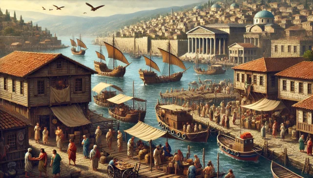
In ancient times, ships often had to wait for favorable winds to sail northward into the Black Sea. The challenging conditions and the scarcity of suitable weather windows (primarily May to September) forced them to anchor at Byzantion’s harbors, paying port fees, buying provisions, and boosting the local economy. Consequently, the strong currents indirectly increased Byzantion’s prosperity, as merchants and sailors contributed to the port’s revenue while awaiting gentler conditions.
The Greek historian Theopompos (4th century BC) describes Byzantion as a bustling trade hub where people spent much of their time near the waterfront, indulging in a hedonistic lifestyle made possible by the wealth brought in by maritime traffic. The city’s identity was shaped by commerce and leisure, intertwined with the rhythms of the Bosphorus current.
7.2. Modern Maritime Trade
Today, the Bosphorus stands as a critical juncture for international shipping, particularly for Black Sea nations seeking global markets. Tankers carrying crude oil, petroleum products, liquefied gas, and assorted cargoes transit the Strait in substantial volumes. Under certain conditions, the strong currents and unpredictable wind patterns can slow or even halt transits, forcing delays and imposing stringent safety measures. The interplay of high traffic density, large ship dimensions, and swift currents underscores the Strait’s reputation as one of the world’s most challenging waterways.
8. Effects of the Current on Vessel Transits
8.1. Northbound Passage (Toward the Black Sea)
Since the primary Bosphorus current generally flows from north to south, ships making headway north encounter a formidable countercurrent. By regulation, vessels must be capable of at least 4 knots of speed against the current; if the current runs 7 knots, the ship needs an 11-knot propulsion capability. Smaller or underpowered vessels may have to wait for calmer conditions, repeating an age-old practice of respecting nature’s whims.
Veteran captains often execute meticulous route planning to exploit weaker current zones along the European shoreline. For instance, passing near Haydarpaşa might subject a vessel to a powerful southward flow, so many prefer to cross toward the European side after Kızkulesi (the Maiden’s Tower), where pockets of countercurrent can assist northbound progress. The approach to Kandilli Point remains one of the trickiest maneuvers. Here, the “Şeytan Akıntısı” can catch the starboard bow of the ship, impeding a timely turn. If the helmsman is late in initiating the turn, or fails to maintain continuous rudder input, the vessel could drift uncontrollably toward Aşiyan on the European shore.
8.2. Southbound Passage (Toward the Sea of Marmara)
While heading south means going with the main current, the journey is not necessarily easier. The sharp turn at Yeniköy (roughly 80–90 degrees) frequently poses hazards for large tankers or bulk carriers. If the bow gets caught in a local eddy while the stern remains in the main current, the vessel can be spun off course unexpectedly, a scenario complicated by the phenomenon known locally as “aynas”—calm patches signifying the convergence of different current streams.
Such accidents are well documented: in 1991, a collision off Kandilli between Madonna Lily and Rabunion-18 resulted in the latter sinking with 20,000 live animals aboard, costing eight lives. After safely navigating the Yeniköy turn, a vessel still has to contend with the swirling waters off Akıntı Burnu, though the crucial apex of the current tends to subside as one approaches Kandilli from the north.
The final hurdle on a southbound transit is the Kızkulesi turn. Should the captain attempt to slow the vessel too drastically, the stern may be forced around by the swift current, pushing the ship dangerously close to Sarayburnu or sending it aground near the Maiden’s Tower itself. Two large tankers in 1998 ran aground at almost the same spot within a month of each other.
9. Accidents, Risks, and Lessons Learned
9.1. Historic Collisions and Groundings
The Bosphorus has witnessed numerous accidents, some involving massive oil tankers. Among the most devastating was the 1979 Independenta collision near Haydarpaşa, leading to an explosion, huge oil spill, and a major environmental disaster. In 1994, the M/T Nassia accident underscored once again the lethal combination of high traffic, narrow channels, and strong currents.
The 14 November 1991 collision between the Filipino-flagged Madonna Lily and the Lebanese-flagged Rabunion-18 near Kandilli resulted in eight casualties and the sinking of the livestock-laden Rabunion-18. Such incidents highlight the absolute necessity of skill, foresight, and local knowledge—traits epitomized by experienced pilots.
9.2. Modern Regulations and Traffic Control
In response to escalating risks, Turkey implemented the Turkish Straits Maritime Traffic Regulations in 1994 and 1998. Vessel Traffic Services (VTS) monitor and guide ships entering the Strait, advising them of changing wind or current conditions and occasionally imposing traffic suspensions. Tankers or large bulk carriers may be required to delay their transit or seek tugboat assistance during adverse weather or strong currents.
Debate continues around the degree to which foreign vessels must take on local pilots. Although the “innocent passage” principle in international law grants free passage through straits, the unique perils of the Bosphorus argue strongly in favor of pilotage to safeguard life, property, and the environment.
10. The Role and Importance of the Pilot
10.1. The “Spiritual Home of Pilotage”
IMO Secretary-General Efthimios Mitropoulos’s remark branding the Bosphorus as the spiritual home of pilotage resonates across the centuries, from Argonautic legends to modern supertankers. No matter how advanced onboard systems become—GPS, radar, ECDIS—nothing substitutes for the intuitive grasp a seasoned Bosphorus pilot has of local current patterns, narrow turns, and shifting underwater contours.
10.2. Maintaining “Maneuvering Advantage”
Navigating the Bosphorus can feel like a duel with the current. The key is preemptive maneuvering: the pilot must foresee the current’s push and initiate the turn or engine orders well in advance. Any delay in response can see the current overwhelming the ship’s momentum, driving the vessel off its intended course. Quick, proactive decisions are vital to maintain control.
10.3. Modern Training and Simulators
Today’s Bosphorus pilots train on advanced simulators that replicate the Strait’s layout and varying conditions—winds, currents, traffic density, and sudden meteorological changes. Yet even the best technology cannot fully emulate the unpredictability and complexity of a real Bosphorus passage. Practical, hands-on experience remains irreplaceable.
11. Strategies to Tackle Bosphorus Currents
11.1. Technological and Structural Approaches
Throughout history, attempts have been made to mitigate or exploit the Bosphorus currents. In the 19th century, the Ottoman Empire built quays and small harbors at select points to offer ships temporary refuge. Modern infrastructural projects—tunnels, suspension bridges, and undersea rail lines—require comprehensive hydrodynamic and ecological studies to ensure minimal disruption to the Strait’s flow.
Contemporary discussions on projects such as Kanal Istanbul also revolve around concerns that altering the natural flow dynamics between the Black Sea and Marmara could have significant ecological and hydrological consequences.
11.2. Voyage Planning and Meteorological Forecasting
Currents in the Bosphorus are highly sensitive to wind patterns. Consequently, shipping companies factor weather forecasts, wind speeds, directions, and up-to-date current reports into their voyage planning. If strong Lodos or Poyraz is forecast, vessels may choose to anchor and wait out the adverse conditions, a modern echo of ancient mariners seeking safe harbor in Byzantion.
11.3. Communication Systems
With VHF radio, AIS, and satellite tracking, vessel positions in the Strait are closely monitored. Should a ship encounter unexpected current shifts or emergencies, the Vessel Traffic Center can be alerted immediately. Nevertheless, human error remains a persistent element in maritime operations, especially under high-pressure conditions where the margin for error is razor-thin.
12. Mythological and Literary Reflections
12.1. Phineus vs. Tiphys: Interwoven Legends
Both Phineus and Tiphys are featured in Argonautic myths as guides or pilots. While some sources portray Phineus as a blind seer who advises the Argonauts on navigating the Clashing Rocks (Symplegades) and the Bosphorus, others emphasize Tiphys, the helmsman of Argo. Regardless, these myths underscore the idea that an expert guide is indispensable to conquer the Strait’s treacherous waters.
12.2. Boreas in Greek Mythology
“Poyraz,” the modern Turkish term for the cold northeast wind, can be traced back to “Boreas,” the Greek god of the northern wind. Boreas was often said to dwell in Thrace and blow fiercely through the Bosphorus. From Homer to Hesiod, ancient writers depict him as a formidable force sailors had to reckon with.
12.3. Currents in Turkish Literature
Prominent Turkish writers—Recaizade Mahmut Ekrem, Yahya Kemal, Ahmet Hamdi Tanpınar—have also drawn inspiration from the Bosphorus’ swirling waters. In their poetry and prose, the unstoppable flow of the current sometimes symbolizes the relentless passage of time and life’s uncertainties. The interplay of calm inlets and raging eddies provides a rich metaphorical backdrop for literary exploration.
13. Conclusion and Final Thoughts
The Istanbul Strait is a singular waterway at the confluence of geography, geology, history, mythology, and maritime practice. For millennia, its currents have challenged seafarers. Today, even advanced engines and technology have not dulled the significance of local knowledge. Bosphorus currents can abruptly shift under the influence of persistent wind changes, occasionally reversing direction entirely and creating dangerous navigation scenarios.
Historically, these waters have functioned like a cradle of maritime evolution—where rope-hauling, cunning contraptions like conical baskets, and the timeless expertise of pilotage have evolved to meet the Strait’s demands. The narrowing between Kandilli and Aşiyan, known for the so-called “Devil’s Current,” or the harsh turns at Yeniköy, testify to how the Strait can be simultaneously alluring and fearsome for mariners.
Geologically, major transgressions of water between Marmara and the Black Sea have alternately flooded and drained regions along the Strait, possibly underlying ancient flood myths. Economically, the Bosphorus has steered ships and commerce into Istanbul’s harbors since the days of Byzantion, shaping both prosperity and culture. In contemporary times, tanker traffic carries oil and gas, highlighting its role on the global energy stage while intensifying the risk of accidents.
No matter how advanced maritime technology becomes, the presence of a Bosphorus pilot remains vital to ensure safe passage. The interplay of powerful surface currents and lurking subsurface flows, the sudden shifts triggered by Lodos or Poyraz, and the labyrinthine coastline with sharp turns all contribute to making the Bosphorus a maritime challenge like no other.
In sum, the Bosphorus is not merely a geographical entity but a dynamic heritage site—imbued with a history spanning from prehistoric times to modern shipping, infused with myth and legend, and governed by the relentless dance of currents and winds. Mariners have long recognized that “you don’t take Bosphorus currents lightly,” and the lessons they’ve gleaned from these waters continue to resonate in the age of satellite navigation and automation.